Technology in the Field of Geology

You might be wondering what the heck is a computer science student doing taking a geology course? Well, besides the class fitting into my schedule, I have always been curious about the natural world, and I wanted to know more. Thanks to my geological studies, I have learned that geology has many facets that often intertwine with the computer science field, particularly in areas like data analysis. Not only am I enthusiastic about geology, but I am also passionate about technology and information being widely accessible to the public. Without computers and accessible technological advancements, the geological field would face significant challenges. Data driven technology helps support geology in numerous ways. Additionally, open source and accessible geological tools are vital for the Earth science field. From the research I have conducted, it’s clear that technology has greatly enhanced geologic mapping and the analysis of geologic data. Before we dive into the nuances of how technology impacts geologic maps and field data, let’s discuss why geologic maps are so important.
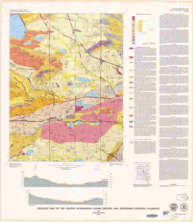
Geologic maps are maps that depict geological features, materials, and the relationships of the landscape and its materials. They are crucial to many earth science fields. To start, geologic maps can help determine the location of energy and mineral resources. Geologic structures that host ore deposits, like faults, are noted on a geologic map, which provides valuable information for ore resource exploration expeditions. Then, companies can decide whether the resource is profitable to mine based on the materials surrounding it and how expensive it is to process those materials. Additionally, geologic maps can be used to locate petroleum and gas deposits. Since geologic maps outline the types of rocks in an area, they are very helpful when analyzing groundwater. By combining information from geologic maps and knowledge of a rock type’s porosity and permeability, groundwater resources can be found. Moreover, this information helps determine the extent of how much contamination has spread through a groundwater resource, allowing for accurate remediation activities. Geologic maps can also help with land use planning. For example, geologic maps can show where the best area is to put major infrastructure projects like highways, landfills, farms, and more (Soller1). Furthermore, geologic maps help geologists map out faults, which show them where to monitor seismic activity. The topography highlighted in geologic maps can also help geologists identify areas at risk for mass wasting events. This list of benefits of geologic maps is not exhaustive, but it emphasizes the crucial role geologic maps have for geologists and society.
How important is technology to the Earth science field anyway, you may be wondering. Well, it plays an important role in two major ways: it helps geologists acquire large amounts of data and allows them to analyze it efficiently. For these two reasons, a lot of geologic research conducted today is data driven. To break this idea down, technology is heavily relied upon to interpret and organize complex datasets. This helps with analyzing patterns, making predictions, and understanding Earth's historical and present processes. According to Than2, data driven research and experiments in the Earth science field lead to something called actionable intelligence. This empowers geologists to make quick, informed decisions about real world issues based on information streamlined by algorithms. Critical decisions like locating groundwater, discovering energy resources, and evaluating the rate at which polar ice caps are melting are supported by vast amounts of data being organized into comprehensive models for geologists. It should be noted that these computerized tools and algorithms do not replace fieldwork for geologists, but they are tools that allow them to work efficiently and even spend more time in the field (Than2). However, the collection and analysis of geological data were not as efficient as they are today.
There was once a time where geology did not rank third in usage of computer resources, following only the defense industry and the internet itself (Than2). Instead, tools like geologic maps were drawn after innumerable hours of physical observations in the field. The emergence of technology in the Earth science field, especially with geologic mapping and data collection, can be attributed to not only technological innovations, but also the removal of barriers blocking the adoption of these resources. Whitmeyer et al.3 discuss that geologists started using technology to aid them in the creation of geologic maps and the collection of data only at the beginning of the 21st century. This is supported by both technological advancements and their increased accessibility to geologists as well. First, GPS finally became widely available for the public in 2000. Then, mobile computers with the capability of operating geographic information system software (GIS) while being out in the field became accessible to geologists. Finally, the widespread availability of virtual globe models on the internet launched geologic mapping and geological data collection into the realm of technology (Whitmeyer et al3). With the history lesson out of the way, let’s explore how technology has impacted the collection of data, creation of geologic maps, and how it has changed data collection protocols.
Collecting information to create a geologic map has changed dramatically. Whitmeyer et al.3 explains that the approach to creating, analyzing, and interacting with geologic maps involves a two-step methodology. The first step is the use of computers with GIS and GPS software to record and interpret data in the field. The second step is inputting data into virtual environments and further interpreting individual components. Originally, geologists used to manually record their measurements and sketch observations on paper. Now, photographs are taken in place of field sketches, and tools like GPS are used to precisely measure topographic features. Digital cartography methods have dramatically evolved because of technology as well. A new mapping approach called plot-on-demand can create a single layered map when requested. This is incredibly useful for analyzing the strength and permeability of geological materials. These maps can also be layered to create a more robust, sophisticated geologic map layout (Soller1). Once the data has been collected and analyzed, it can then be further interpreted with software capable of viewing the topography in three dimensions. This software provided by companies like NASA and Google is free for geologists to display field data. This allows geologists to interact with the map and review individual components like faults, structures, outcrops, and more. Interestingly, geologists can program in these environments. They can make scripts in keyhole markup language, KML, to better manipulate the environment and data they are evaluating (Whitmeyer et al3). Due to the increasing use of technology in the creation of geologic maps, observation and measurement techniques need to be standardized to ensure consistency and accuracy with the collected data.
Geologists are not required to use the same software when conducting field observations. However, there are issues when symbology and information indexing are not consistently required in the creation of geologic maps. Both Soller1 and Whitmeyer et al.3 argue that the lack of standardized geologic symbols and terminology across GIS software and geologists’ field notes has slowed the availability of information from geologic maps and data collected out in the field. If information is classified in a uniform, standardized way, other geologists can easily interpret the data even if they did not create the map. Making information available and accessible to other geologists would not just promote collaboration, but it would also accelerate the compiling and organization of data into databases (Soller1). Employing databases to catalog complex data and geologic maps is difficult due to the amount of data that needs to be stored and the technical requirements to do so. See, there needs to be sufficient hardware resources and servers to hold all of the information. Alongside the storage of data, an interactive layer or piece of software is needed to allow the geologists to interact with the stored data. That does not include any software used to analyze the data. Additionally, the process of making geologic maps is not a “one and done deal”. Instead, geologic maps need to be consistently updated (Soller1). You may be wondering why this is. This is because databases are constantly maintained and updated to best support the users’ needs. Therefore, the data stored in them needs to be consistently accurate, so it must be updated frequently. With geologic map data streamlined and compiled into databases, the integrity of the data is easy to preserve, manage, and locate. This makes the information easily accessible for both learning and collaboration. Next time you read a geologic map online, you will hopefully appreciate the effort it took for it to be accessible to you.
As you can tell, access to new, innovative technologies in geology enhances decision making, improves the precision of data collected, and allows geologic information to be easily accessible. Without modern technology, we would not have as many advancements in the field of geology. It could also be argued that we would not have as much innovation in the technology field today if it weren’t for the demand generated by geologists. I don’t know about you, but I look forward to seeing how new technology continues to revolutionize geology and help make geological knowledge accessible to everyone.

 Rock Talk