How did the Rocky Mountains Form?

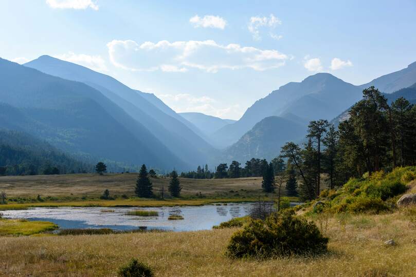
Like many Coloradans, I have marveled at the Rocky Mountains every chance I can get. However, I have always wondered how their majestic peaks came to be. You can imagine my surprise when I found out that the origins of these mountains are not only a mystery, but that they took millions of years to form as well! As soon as I learned about this, I was hooked, and I knew that I needed to know how exactly the Rocky Mountains formed. If you're anything like me, I am sure you are all interested in their origin story as well now. To preface, I think the origin story of the Rocky Mountains is best told split up into five chapters: the first set of the Rocky Mountains, when Colorado was submerged underwater, the first uplift, the hotly debated second uplift, and their erosive downfall. So, how exactly did the Rocky Mountains form?
Well, the story of how the Rocky Mountains came to exist has puzzled geologists for many years. You see, the Rockies are a beautiful, yet confusing anomaly. These continental, landlocked mountains did not form like their Himalayan and Appalachian counterparts. To start, the Rocky Mountains are not near an active tectonic plate boundary, they are not even near an intra-plate boundary. To create continental mountains, the area needs to have two active tectonic plates colliding into each other. Secondly, the Rocky Mountains are not rooted in the crust. Collisional mountains typically form a “root” in the crust beneath them during a tectonic collision event. When the plates collide, the crust gets smashed together, lifting it up. Since the crust is forced upwards, it causes the crust to become shorter horizontally. This process of vertical crustal thickening and horizontal shortening creates a mountain root which helps keep the mountain stable in the crust. Finally, the surrounding terrain does not match what it should be for collisional mountains. For example, the Colorado Plateau lacks geologic structures, like faults and folds, which would prove that the region was a byproduct of collisional forces even though it is above sea level (Abbott1). With all these anomalies involving the origin of the Rocky Mountains and its surrounding regions, let us dive into the anticipated origin of the mountains and the region.
The area where the Rocky Mountains currently reside has a rich geological history. Before we had the gorgeous Rocky Mountains, there were the Ancestral Rocky Mountains around 330 to 300 million years ago during the Late Paleozoic Era. During this time, the landscape of the region was covered with tropical oceans and swamps (“Geologic Time Scale”2). So, the Ancestral Rocky Mountains were essentially islands that originated from a tropical ocean when Colorado was close to the equator. Over the course of about 150 million years in the Mesozoic Era, these mountains were dramatically transformed by weathering and erosion which brought their elevation down to sea level. Weathered shale and sandstone from the Ancestral Rocky Mountains make up the present-day Morrison Formation. After another 50 million years in the Late Cretaceous Period, the sedimentary remains of the Ancestral Rocky Mountains and Colorado itself were submerged by the sea. These remains would be buried and cemented and become the Dakota Sandstone Formation (Abbott1; “Geologic Time Scale”2). Meanwhile, the sea that submerged the region is known as the Western Interior Seaway. This sea connected the Arctic Ocean to the Gulf of Mexico. During this time, Colorado was below sea level because it was weighed down by not just the sea, but all the sediment being continuously deposited and compacted there as well. Once the sea receded towards the end of the Cretaceous Period, around 70 million years ago, the Rocky Mountains began to form (Abbott1). With the backstory of the region dissected, let’s dive into the Cenozoic Era and discover how the Rockies were formed.
The initial Rocky Mountain building event is thought to have occurred between 70 million to 45 million years ago. It began at the very end of the Cretaceous Period and spanned into the early Paleogene Period. This building event is called the Laramide Orogeny, and it not only marks the beginning of the Rocky Mountains, but it also highlights the beginning of the Cenozoic Era (“Geologic Time Scale”2). This orogeny began due to the oceanic Pacific plate going under the continental North American plate in a process called subduction. This subduction event is thought to have occurred at a very shallow angle, which generated a lot of energy known as compression stress. Said stress traveled far inland to where the present Rocky Mountains are today (HISTORY4). This type of energy causes rocks to squeeze together and can lead them to fold and buckle upwards. This not only formed the Rockies, but also created features that one would see at collisional mountain ranges even though two plates did not collide during this orogeny. For example, there are thrust faults present at many of the bases of the mountains that make up the Rockies (Abbott1). These faults are unique to compressional mountain ranges and occur from compressional stresses which cause one slab of rock to be pushed up over another slab. After the region faced compressional stresses and was uplifted, a series of events caused many of the mountains to be eroded and buried. Mechanical weathering processes like rivers and frost wedging ate away at the mountains and deposited the sediments in the surrounding regions (HISTORY4. However, volcanism from the surrounding region, like the La Garita Caldera, caused pyroclastic debris to settle and bury some of the mountains (Abbott1). These two processes caused the mountains to lose a substantial amount of height, which leads to a debated theory about how we even have the present-day Rocky Mountains.
Now here is where the drama begins. It is a hotly debated topic whether the Rockies faced a second orogeny or not. See, some geologists theorized that further uplifting and erosion were what unearthed the Rockies again. Meanwhile, other geologists agree that a second orogeny would have had to occur before the additional tilting and erosion. The original uplift can be explained by the shallow subduction, but their lack of a crustal root and their other above sea level features cannot be explained by that. So, geologists theorize that a second orogeny occurred due to the mantle being unexpectedly warmer than normal. Increased heat in the mantle would cause the rocks to expand and uplift the overlying crust. The theorized uplift where the mantle was warmed is called the Alvarado Ridge. The mountains that survived from the previous erosive and burial processes are thought to be on top of this ridge. This is why the Rocky Mountains in Colorado are taller than the rest in the mountain chain. Additionally, this second orogeny could explain other features in the area. This could be the reason the Colorado Plateau and Great Plains are elevated above sea level as well as the abundance of hot springs in the area. The only issue with this theory is when it happened. With the mantle being warmer, it could have triggered some of the volcanism that buried some of the Rockies to begin with. However, this would mean that the origin of the Alvarado Ridge and the eruption of La Garita Caldera would have happened within a very short span of geological time in comparison to the original orogeny. Geologists estimate that the mantle warming up and the second orogeny would have occurred anywhere from 38 million years ago to 24 million years ago (Abbott1). If this is the reason the Rocky Mountains do not have a crustal root, then it is assumed that they are only stable due to the thick crust being more buoyant than the hot mantle underneath it (“Geology of Rocky Mountain National Park”3). With the debated second orogeny discussed, you may be wondering what actually shaped the Rockies we see today.
If this second orogeny did occur, then more erosive processes would have to take place to produce the beautiful geography we know and love today. One of the most notable erosional processes was the work of glaciers. See, glaciers are powerful enough to turn rolling hills into U-shaped valleys and jagged cliffs. They can also carry sediment, both enormous and small particulates, across vast distances. Nearby regions often contain boulders and sediments from the Rocky Mountains due to erosion from the glaciers (HISTORY4). As mentioned before, glaciers helped form features like U-shaped valleys, but they also formed lateral moraines and caused striations on the surface rocks in the region.
Well, there is the story of how the Rocky Mountains came to be, or at least one of the more accepted stories by geologists. Since these mountains formed in such anomalous circumstances, their exact origin is difficult to pinpoint. Thanks to relative and absolute dating tools, we can estimate when the orogenies occurred. Studying the Rocky Mountains has led to invaluable information about plate tectonics and mountain building orogenies. If new theories were not being crafted and tested, then we would still have no idea how to solve the mystery of the Rocky Mountains. Now, you all understand the theories and explanations behind how the Rocky Mountains and their surrounding regions were formed.

 Rock Talk